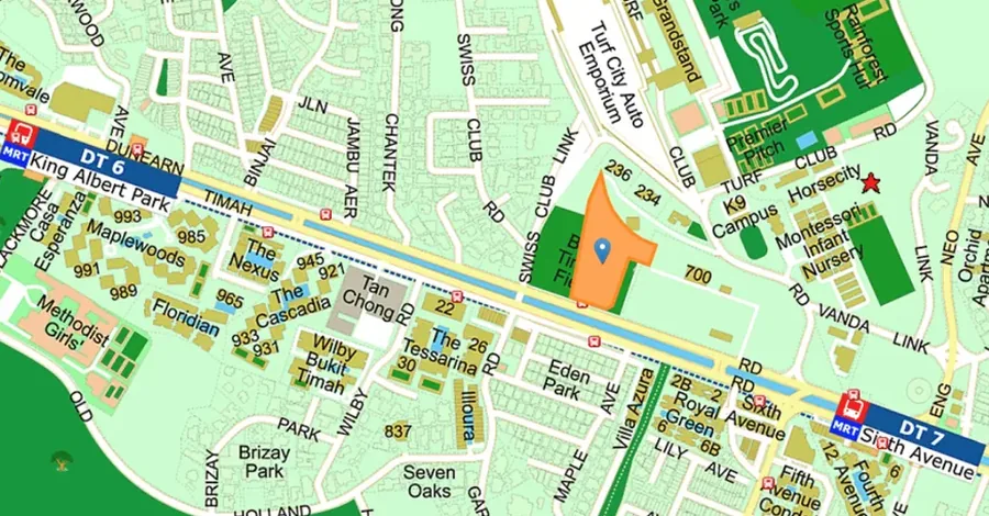
The Vanda Green occupies a Dunearn Road site in the Bukit Timah planning area, within the Swiss Club subzone. This is the stretch where the Dunearn and Bukit Timah arterials run in parallel and the landed estates — Vanda, Swiss Club, Eng Neo — begin immediately behind them.
The Vanda Green Address and District
The site is in District 11, in the Central Core Region. It is worth flagging one point of confusion honestly: the Bukit Timah stretch of Dunearn Road sits close to the boundary between District 10 and District 11, and published references describe this parcel both ways. The postal sector covering Swiss Club Road and the Vanda roads places it in District 11, which is how this site records it. Buyers comparing listings across portals may encounter both labels for the same land.
Rail Access from The Vanda Green
Sixth Avenue station on the Downtown Line is approximately 630 metres from the site. The Downtown Line runs through Botanic Gardens, where it meets the Circle Line, then Newton for the North South Line, Little India for the North East Line, and onward into Bugis, Promenade and the Bayfront. For a commute into the central business district it is a single ride.
Beyond the current network, a Turf City station on the Cross Island Line is planned within the wider precinct. The Cross Island Line is designed as an east–west spine, and its arrival would give this part of Bukit Timah a second line and a materially different connectivity profile. It should be assessed as a planned improvement rather than an existing one.
Buses and Roads Around The Vanda Green
The nearest bus stop sits about 80 metres from the site, just after Swiss Club Road. For short local journeys — the market, a school gate, Coronation Plaza — that proximity does more day-to-day work than the rail distance.
Dunearn Road and Bukit Timah Road operate as a paired one-way system, carrying traffic into town on one and out towards Upper Bukit Timah on the other. The Pan-Island Expressway is close, and the Bukit Timah Expressway a little further north for journeys towards Woodlands and the Causeway. Orchard Road is a direct run along Bukit Timah Road. The connectivity guide goes through this in detail.
The Bukit Timah Turf City Precinct Around The Vanda Green
The former Bukit Timah Turf City is being planned as a new housing estate. Public planning material describes an eventual 15,000 to 20,000 homes across public and private housing, supported by new transport infrastructure, community amenities and an extensive green network. Twenty-two heritage buildings, including the Grandstand and stable blocks, are proposed for conservation and repurposing.
The planning material also notes that road improvements to accommodate traffic from the new developments — including widening of Eng Neo Avenue, Dunearn Road and Bukit Timah Road — are being studied, and that developments in the precinct will provide fewer parking lots on the expectation of reduced private-vehicle reliance. These are the trade-offs of an early position in a precinct still being built out, and they belong in an honest assessment alongside the upside.
Green Space Near The Vanda Green
Maple Lane Park is approximately 240 metres from the site. Wider afield, the Rail Corridor at Bukit Timah, the Singapore Botanic Gardens, the Bukit Timah Nature Reserve and the Central Catchment Nature Reserve form one of the densest concentrations of accessible green space on the island. Planning material for the precinct indicates that much of the Eng Neo Avenue forest is to be retained. The green corridor guide covers each.
Distances from The Vanda Green
| Destination | Type | Approx. distance |
|---|---|---|
| Bus stop after Swiss Club Road | Bus | 80 m |
| Little Paddington Preschool (Tanglin) | Preschool | 180 m |
| Bukit Timah Family Clinic & Surgery | Healthcare | 210 m |
| Maple Lane Park | Park | 240 m |
| La Petite Ecole Singapore | International school | 580 m |
| Sixth Avenue MRT (Downtown Line) | Rail | 630 m |
| Methodist Girls' School (Secondary) | School | 980 m |
| Methodist Girls' School (Primary) | School | 1.02 km |
| National Junior College | Junior college | 1.42 km |
| Bukit Timah Plaza | Shopping | 1.59 km |
| Bukit Timah Market & Food Centre | Hawker centre | 1.89 km |
| Bukit Timah Community Club | Community | 2.39 km |
Straight-line distances recorded in the land sales data. Indicative only — verify with OneMap before relying on them.